The Google Crisis Response team has assembled a resource page to help track affected areas and provide updated emergency information for the millions affected by flooding in Jakarta. We also have a mobile page with emergency contact numbers and lists of shelters, and enhanced search results on google.co.id to provide information directly when people search. We’ve also included this information in our FreeZone service to reach affected users on feature phones.
On both the page and map, which are available in English and Bahasa Indonesia, you'll see an update on flood locations and related data such as traffic conditions in areas affected by the flooding.
To share the page or embed these maps on your own site, click "Share" at the top of the page.
We’ll update the content as more information becomes available.
Posted by Alice Bonhomme-Biais, Software Engineer, Google Crisis Response
We hope you’ve had a chance to try the new Google Maps app for iPhone (announced last week and available for download in the Apple App Store). The app is designed to be simple—just to work whenever you need it. Still, we have a few tips to make finding things with Google Maps even faster and easier. All the tips are collected on our site but here a few of my favorites:
Swipe to see more. In Google Maps a wealth of information is often just a swipe away. Whether you’re looking at search results or directions, you can swipe the bottom info sheet left and right to see other options. To get more details on any of the results, swipe that info sheet upward (or just tap it—that works too). Even with the info sheet expanded, you can swipe to see those other results.
Place a pin. Get more information about any location by just pressing and holding the map. The info sheet that pops up tells you the address, lets you save or share the place, and best of all, brings up...
Street View. By far the easiest way to get to Street View is placing a pin. Tap the imagery preview on the info sheet to enter into Street View, then explore! I recommend the look-around feature (bottom left button) which changes what you’re looking at as you tilt and move your phone.
Want to learn more? See the rest of our tips on the site. And as you explore the app on your own, share your own tips using #googlemaps. Most of all, enjoy discovering your world.
Posted by Vicky Tait, Consumer Operations, Google Maps
While millions of people eagerly await Christmas Day, Santa and his elves are keeping busy at the North Pole. They’re preparing presents, tuning up the sleigh, feeding the reindeer and, of course, checking the list (twice!) before they take flight on their trip around the world.
While we’ve been tracking Santa since 2004 with Google Earth, this year a team of dedicated Google Maps engineers built a new route algorithm to chart Santa’s journey around the world on Christmas Eve. On his sleigh, arguably the fastest airborne vehicle in the world, Santa whips from city to city delivering presents to millions of homes. You’ll be able to follow him on Google Maps and Google Earth, and get his stats starting at 2:00 a.m. PST Christmas Eve at google.com/santatracker.
Simulating Santa's path across the world—see it live Dec 24
In addition, with some help from developer elves, we’ve built a few other tools to help you track Santa from wherever you may be. Add the new Chrome extension or download the Android app to keep up with Santa from your smartphone or tablet. And to get the latest updates on his trip, follow Google Maps on Google+, Facebook and Twitter.
Get a dashboard view of Santa's journey on Google Maps
The Google Santa Tracker will launch on December 24, but the countdown to the journey starts now! Visit Santa’s Village today to watch the countdown clock and join the elves and reindeer in their preparations. You can even ask Santa to call a friend or family member.
We hope you enjoy tracking Santa with us this year. And on behalf of everyone at Google—happy holidays!
Posted by Brian McClendon, VP of Google Maps and Google Earth
People around the world have been asking for Google Maps on iPhone. Starting today, we’re pleased to announce that Google Maps is here—rolling out across the world in the Apple App Store. It’s designed from the ground up to combine the comprehensiveness and accuracy of Google Maps with an interface that makes finding what you’re looking for faster and easier.
The app shows more map on screen and turns mobile mapping into one intuitive experience. It’s a sharper looking, vector-based map that loads quickly and provides smooth tilting and rotating of 2D and 3D views. The search box at the top is a good place to start—perhaps by entering the name of a new and interesting restaurant. An expandable info sheet at the bottom shows the address, opening hours, ratings and reviews, images, directions and other information.
At the heart of this app is our constantly improving map of the world that includes detailed information for more than 80 million businesses and points of interest. Preview where you want to go with Street View and see inside places with Business Photos to decide on a table or see if it’s better at the bar. To get you there, you’ve got voice-guided, turn-by-turn navigation, live traffic conditions to avoid the jams and if you want to use public transportation, find information for more than one million public transit stops.
The world around us is constantly changing and, thanks to feedback from you, we make tens of thousands of daily updates to keep Google Maps accurate and comprehensive. Here’s a helpful hint for the new app: if you see something off, simply shake your phone to send us feedback.
To complete the Google Maps ecosystem, we’re also releasing the Google Maps SDK for iOS, and a simple URL scheme to help developers use Google Maps when building their beautiful and innovative apps.
The new Google Maps app is available for the iPhone and iPod Touch (4th gen) iOS 5.1 and higher, in more than 40 countries and 29 languages, including Chinese, Dutch, English, French, German, Italian, Japanese and Spanish. Please note some of the features mentioned in this post aren’t available in all countries.
Visit the App Store today and download the new Google Maps app. We believe this delightful new experience is a great starting point—and we’ll continue to improve Google Maps for you, every day.
Posted by Daniel Graf, Director, Google Maps for Mobile
A year ago we released Street View imagery of areas in Northeastern Japan that were affected by the March 11, 2011 earthquake and tsunami. Our hope was that the 360-degree panoramas would provide a comprehensive, accurate and easy-to-use way for people around the world to view the damage to the region by enabling a virtual walk through of the disaster zones.
The panoramas were only the start of our digital archiving project. Last month we took the next step—using the technology behind Business Photos to photograph the inside of buildings in Northeastern Japan that were heavily damaged but still standing. We worked with four city governments in the Tōhoku area to photograph more than 30 buildings, and today we’re bringing this imagery to Google Maps and our Memories for the Future site. The new imagery enables you to walk through the buildings and switch between floors to get a first-hand glimpse at the extent of the destruction caused by the earthquake and tsunami.
The timing of the project was critical. There has been a strong debate in these areas whether to keep the buildings up as a permanent reminder of the tragedy or to tear them down to allow emotional wounds to heal. After long consultations with their citizens, many local governments have decided to move forward with demolishing the buildings. Knowing this, we quickly moved to photograph the buildings before they started to be dismantled.
The panorama below shows an elementary school very close to the ocean. Thankfully, all the students survived the disaster as they had been well drilled to rush to escape at the sound of tsunami warnings.
Other sites include Rikuzentakata city public housing, a building that physically demonstrates the heights of the tsunami wave. Everything up to the fourth floor is completely ruined, but the fifth floor remains mostly unscathed.
We’ve also captured imagery of Ukedo Elementary School and a few other buildings in Namie Town—located in the restricted area (PDF) within 20km of the Fukushima Daiichi nuclear power plant. In the elementary school, you can see holes in the gym floor, where a graduation banner still hangs in the gym, though the ceremony never took place.
We’ll continue to photograph more buildings in two Iwate Prefecture cities, Ōfunato and Kamaishi, over the coming weeks. By the end of the year, we also hope to complete the collection of imagery from five new cities in the Miyagi prefecture. We look forward to making this new imagery available as soon as it’s ready to pay tribute to both the tragedy of the disaster and the current efforts to rebuild. City governments in Northeastern Japan that are interested in this digital archiving project are welcome to contact us through this form.
Posted by Kei Kawai, Group Product Manager, Street View
More than a billion people use Google Maps each month to find their way around town and around the world. To help these people get exactly the information they need, the Google Maps team works constantly to ensure that the geographic data behind our maps is comprehensive and accurate. As part of this ongoing effort, we’ve just released updated maps for 10 countries and regions in Europe: Andorra, Bulgaria, Estonia, Gibraltar, Hungary, Latvia, Lithuania, Slovakia, Slovenia and Spain.
Today’s update is part of a project called Ground Truth that began in 2008. Through this initiative, we acquire high-quality map data from authoritative sources around the world and then apply a mix of advanced algorithms, supplemental data (including satellite, aerial and Street View imagery), and human input to create a map that corresponds as closely as possible to the real-world facts that you’d find if you were to visit that location.
For example, this update adds a new 70-km section of Bulgaria’s Trakiya motorway, which opened recently to drivers but hasn’t been reflected on most maps of the region until now.
But roads and highways alone don’t define the character of a place, and they aren’t always sufficient to help you get around. So Google Maps also integrates information such as walking paths, ferry lines, building outlines, park boundaries, university campuses and more—providing a richer, more comprehensive and more realistic experience for locals, visitors and armchair travelers alike.
Our new map of Spain, for example, not only shows the famous Museo del Prado and Parque del Retiro in Madrid, but also includes additional building models in surrounding neighborhoods, the well-known “Estanque” (or pond) in the center of the park, and detailed walking paths throughout both the park and the nearby Royal Botanical Gardens.
Of course, the world is always changing, and we want Google Maps to change with it. So when you notice something on the map that needs updating, let us know through the simple “Report a problem” tool in the lower right corner of the map. We’ll make the appropriate changes to the map—often within just a few minutes or hours of reviewing and verifying your feedback! This tool launches today in the 10 places where we’ve updated our maps, and is already available in dozens of other countries around the world.
With today’s release, the maps that we’ve built through our Ground Truth initiative are now available in a total of 40 countries worldwide. To see the progress we’ve made to date, take a look at the image below (click for a full-size version).
We hope today’s launch of more comprehensive and accurate maps of Europe will help you explore amazing places from Barcelona and Budapest to Bratislava and beyond.
Posted by Brian McClendon, VP Google Maps and Google Earth
For those of us in the northern hemisphere, the days are getting shorter and the temperatures are dropping. To help prepare for the winter ahead, we’re adding more detail and imagery to the map for a variety of chilly destinations, making them more comprehensive and accurate than ever. Starting today, you can virtually experience the Canadian Arctic through new panoramic Street View images of Cambridge Bay and detailed maps created with the help of local community members. And if you’re planning a winter getaway, you can preview the slopes of more than 90 ski and snow resorts around the world, adding to dozens that are already available via Street View today.
Canada’s Arctic When we visited Canada’s far north this past August, we worked with the nonprofit group Nunavut Tunngavik and the residents of Cambridge Bay to improve the map of this remote, but culturally rich, Nunavut hamlet. The map this community helped build using Google Map Maker, as well as the 360-degree images we collected using Street View trike and tripod technologies, is now available for all the world to see on Google Maps.
Explore the intersection of Omingmak (“musk ox”) Street and Tigiganiak (“fox”) Road
Ski and snow resorts across the globe You can also view some of the world’s best runs right on Google Maps before you get there. Whether you’re looking to discover a piste you’ve never tried before, or just want to take in some winter wonderland scenery, we’ve added Street View imagery for resorts across Europe (including runs in Switzerland, Austria, Norway, Sweden, Italy and Spain), Canada (including runs in British Columbia, Alberta and Ontario) and the U.S. (including runs in Utah and Michigan).
For example, take a look at Sölden, a popular ski resort in the Ötztal valley of Tyrol, Austria. It’s not just tourists who flock there every year, but fans of professional skiing—Sölden regularly hosts the giant slalom competition as part of the Alpine World Cup in late October.
You can also visit Canyons Resort in Park City, Utah. With 19 chairlifts, 4,000 acres of skiable terrain and an average of 355 inches of snow each winter, Canyons is the largest ski and snowboard terrain park in the state.
Visit the to see some of our favorite images of the Arctic and resorts available on Google Maps. As winter sets in, we encourage you to experience it all from the comfort (and warmth) of your couch—or check it out online, then dig out your thermal underwear and snow boots to hit the slopes!
Posted by Ulf Spitzer, Program Manager, Google Street View
Inspiration comes in many shapes and forms. For U.S. Marine Sgt. Winston Fiore, it was a news article about the International Children’s Surgical Foundation (ICSF) and Dr. Geoff Williams, who provides free facial-reconstructive surgeries for children with cleft lips/palates in developing countries. Although cleft palates are quite correctable, if left untreated the deformity can cause serious health issues. Many children don’t have the surgery because the cost of each procedure ($250 USD) is out of reach for their families.
Inspired to do something to help, Winston set out on a 5,000-mile trek across Southeast Asia to raise money and awareness for the ICSF—a mission he dubbed Smile Trek. Armed with sturdy boots, a 20-pound vest carrying essentials and an Android phone with Google Maps, Winston set off on his mission in October 2011. In the last year, he has walked (yes, walked!) through Brunei, China, Laos, Malaysia, Philippines, Singapore, Taiwan, Thailand, and Vietnam. Along the way he’s met countless individuals who have contributed to his cause, whether it was a place to stay, a hot meal or a monetary donation on his website.
Trekking along: Winston, standing in front of a durian fruit stand near Sematan, the westernmost town of Malaysian Borneo
Out on the road, Winston’s Android phone and Google Maps became “the hub” of his entire operation. He used Google Maps to find accurate and easy-to-use walking directions everywhere he went, whether it was through remote villages and farms, down tiny dirt roads, or across rice paddies and desolate sugar cane fields. “Walking directions in Google Maps were critical to my trek. The directions were accurate and efficient—it’s essential to take the shortest route when you’re walking 20-25 miles each day,” said Winston. “But the best part was being routed onto roads and trails through areas I otherwise never would have discovered with, say, driving directions, or even a physical map.”
View the complete map of Winston's journey on his site
In addition to using Google Maps, Winston relied on many other Google products during his trek. He used Google Latitude to keep his family, friends and supporters informed of his whereabouts, and MyTracks to record his speed, distance and the places he visited. He also used Google Translate to communicate with locals, and in one case found it essential: when bit by a stray dog outside of Bangkok, he typed "I got bit by a dog, can someone take me to a hospital?" into his app. A taxi driver took him to the hospital, where he got 11 shots!
Today, after walking 5,000 miles in 408 days, Sgt. Fiore completes his journey, with more than $65,000 raised for ICSF. The money will help to fund more than 200 life-saving surgeries for children in Southeast Asia and other parts of the world. If you’d like to contribute to the International Children’s Surgery Fund and Winston Fiore’s effort, we encourage you to visit smiletrek.org.
Posted by Jennifer J. Chen, Product Manager, Google Maps
Thanksgiving is about sharing, giving thanks and connecting with family and friends. Yet, all too often we get caught up in the holiday rat race—the mad dash to the airport, the supermarket, the mall—and forget to take time out to enjoy the holiday.
To kick off the holidays this year, we wanted to crank up the fun and tone down the stress. So we did a little planning for you and created a one-stop-Google-shop to get you through the week.
Cooking With tools like recipe search and YouTube cooking videos that show you the right (and wrong) ways to carve a deep-fried turkey, Google can help you master your Thanksgiving meal with lots of laughs along the way. You can also join members of the Google+ cooking community for cooking lessons over live hangouts. Learn how to make new dishes like pumpkin brulee for the sweet tooths at the table or mix things up this year with a vegan-friendly feast.
Connecting Though we can’t control the skies and guarantee a turbulence-free flight home, we can help minimize the time you spend waiting around, with real-time flight updates. Download the Google Search App to get flight updates on the go. And don’t forget to download TV shows, music and more from Google Play to stay entertained on board.
Of course, for those of you who couldn’t make it home this year, you can still get everyone together with Google+ Hangouts. Try scheduling a hangout to video chat with up to nine people you’d otherwise miss this holiday.
Sports Whether you’re rooting for the Cowboys or the Jets, Texans or the Patriots, we can help you stay on top of all the scores and stats. If you’re on the run, ask for real time scores or game details using Voice Search on the Google Search App.
Shopping This year Black Friday starts on Thursday, with Wal-Mart, Target and Toys R Us all kicking off sales on Thanksgiving night. To help you get a head start on the deal-seekers, try our new shortlists, a super-simple alternative to sharing lists of links or bookmarks, as well as 360-degree imagery for many of the season’s hottest toys on Google Shopping. For those of you brave enough to face the masses at the store, use indoor Google Maps to get in and get out of the mall fast.
By putting all your favorite Google features in one place, we hope we can help make things just a little bit easier this Thanksgiving—giving you more time to make memories with those who matter most and enjoy every last bite of that much deserved pumpkin pie. Visit our Thanksgiving hub to get started.
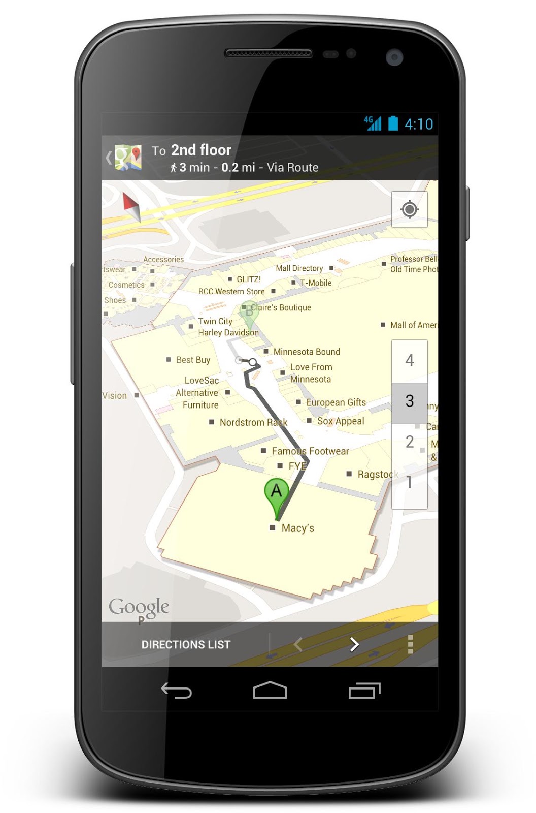
The holiday shopping season is upon us. Your favorite retail stores are already playing holiday tunes, promoting sales, and decking out their displays in red and green. But if flashbacks of people rushing all around you frantically trying to find gifts for everyone on their lists are giving you anxiety, fret not. This year you can use indoor Google Maps on your Android device to stay cool, calm, collected and most of all, one step ahead of the crowd.
On Black Friday and throughout this holiday season, simply zoom in to a participating store on Google Maps to devise your shopping game plan. An indoor floor plan with helpful labels will automatically appear, and the familiar “blue dot” icon will help you figure out the fastest way to the accessories department, the food court when you need to refuel, and the closest restroom or ATM when you need a break from your marathon shopping session. For many locations, you can even get indoor walking directions to find the best route from one store to the next.
Indoor Google Maps for Mall of America in Bloomington, MN (left) and for Macy's in New York, NY (right)
These accurate, easy-to-use indoor maps are available for a number of popular retail locations across the globe including many local malls and select Best Buy, Nordstrom, Macy’s, Bloomingdale’s, Harrod’s, Selfridges, John Lewis and other stores. With the help of your Android device, you can beeline it to the camcorder you’ve been eyeing for your dad, and then quickly make your way to that sweater you know your sister will love. For list of additional venue partners, including some in Belgium that just became available today, check out this list.
Indoor Google Maps for West Edmonton Mall in Edmonton, Alberta, Canada (left) and for Nordstrom in Seattle, WA (right)
We hope these indoor maps make finding your way in and around retail stores easier, less stressful and more efficient this holiday season. To access them, simply update Google Maps on your Android by visiting Google Play on your phone or desktop. Happy holiday shopping!
Posted by Cedric Dupont, Product Manager, Google Maps