More resources for those affected by the Japan earthquake and tsunami

(Cross-posted from the Google.org Blog)

Like the rest of the world, we’ve been transfixed by the images and news coming out of the northeastern part of Japan over the past six days. Our hearts go out to those who have been affected by this devastation and we’re deeply grateful to those who are working to keep us safe. In the meantime, Googlers in Japan and elsewhere around the world have been working around the clock to try and help improve the flow of information. Here are some of the recent developments we’ve been working on:

Centralized information
Our Crisis Response page—now in Japanese, English, Chinese and Korean—organizes all of Google’s efforts, with links to valuable resources such as emergency hotlines, Person Finder, blackout schedules, maps and links to relief organizations receiving donations. Ninety-three percent of mobile users in Japan don’t have top-of-the-line smartphones, so we’ve recently optimized this Crisis Response page to make it more readable for a wider range of devices. You can also access that version by scanning this QR code:

Person Finder
Within the first two hours of the earthquake, we launched Person Finder so people can enter the names of those they’re looking for or have found. You can now also search by entering mobile phone numbers to see if they match any listings. And as with the Crisis Response page, Person Finder has also been optimized for those without smartphones. There are currently more than 250,000 records in the database (including names shared with us by NHK, the national broadcaster in Japan) and we’ve heard several reports of people who have found their loved ones safe.

To help the many people in shelters get word of their whereabouts to loved ones, we’re also asking people in shelters to take photos of the handwritten lists of names of current residents and email them to us. Those photos are automatically uploaded to a public Picasa Web Album. We use scanning technology to help us manually add these names to Person Finder; but it’s a big job that can’t be done automatically by computers alone, so we welcome volunteers with Japanese language skills who want to help out.
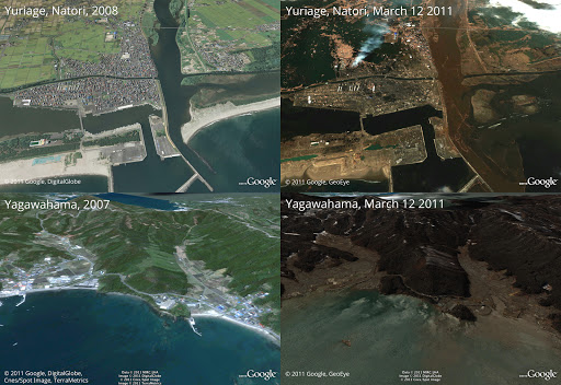
Satellite images
We’re also working with our satellite partners GeoEye and DigitalGlobe to provide frequent updates to our imagery of the hardest-hit areas to first responders as well as the general public. You can view this imagery in this Google Earth KML, browse it online through Google Maps or look through our Picasa album of before-and-after images of such places as Minamisanriku and Kesennuma.

Mapping
You can follow developments on the ground by looking at several maps that track changing developments. We’ve mapped rolling blackouts for areas that are affected by power outages. With data given to us by Honda, you can now see which roads have been recently passable on this map or this user-made Google Earth mashup with new satellite imagery. We’re also constantly updating a master map (in Japanese and English) with other data such as epicenter locations and evacuation shelters. And with information from the newspaper Mainichi, we’ve published a partial list of shelters.

Translation
Use Google Translate for Japanese and 56 other languages. You can paste in any text, or enter the address of any web page for automatic translation. We also just released an early experimental version of Google Translate for Android to help non-Japanese speakers in affected areas.

Donations
Visit our Crisis Response resource page to find opportunities to donate. When you donate to Japan relief efforts through Google Checkout, we absorb processing fees—so 100% of your money goes to the organizations. Google has also donated $250,000 to help the people of Japan recover.

To keep up with the latest developments on our efforts in Japan, follow @googlejapan (tweets are mostly in Japanese) or @earthoutreach (for our mapping and imagery efforts) on Twitter.

Post-earthquake imagery of Japan

(Cross-posted from the LatLong Blog)

In response to the devastating earthquake and subsequent tsunami that struck Japan, we’ve worked with our satellite imagery providers to get the latest available data of the areas affected most.

To view this high-resolution imagery, courtesy of our partners at GeoEye, download this KML file and explore it in Google Earth. You can also explore the imagery with Google Maps, or have a look at this Picasa album of before-and-after shots. Here’s a sample:

Before and after the earthquake and tsunami. Above is Yuriage in Natori, below is Yagawahama; both are in Miyagi prefecture. High-resolution version of this photo.

We’re working to provide this data directly to response organizations on the ground to aid their efforts. We hope this new updated satellite imagery is valuable for them as well as everyone else following this situation to help illustrate the extent of the damage.

You can find more information regarding the disaster and resources for those in need at our Crisis Response page in English and Japanese. You can also follow @earthoutreach on Twitter to stay up to date with our mapping and imagery efforts.

Assembling resources following the earthquake in Japan

(Cross-posted from the Google.org Blog)

I was in the middle of writing code when the Google Japan office, on the 26th floor of Roppongi Hills in Tokyo, started shaking slowly. The rocking gradually increased, and I looked out the window to see the surrounding buildings all swaying ominously. Although alerts from the building urged us to evacuate via the emergency stairs, I couldn't help but stay and search for information about the earthquake’s epicenter and scale. Amidst a series of aftershocks rocking our office, a small group of us in Tokyo and several other Google offices started gathering information about the earthquake to create the Crisis Response information page.

As someone who experienced the Kobe earthquake 16 years ago when I was at university, I cannot forget the immediate desire for information. There was no way to find out where people's family and friends were, if transportation would be available to get us home, and most importantly, whether we would be able to find shelter.

This experience helped me remember that during a crisis, information about shelters can become increasingly muddled. Together with our Google Crisis Response team, we decided to organize existing public information from local governments about the concerned areas. Because of the very high volume of web traffic yesterday, this proved difficult to access. Collaborating with the Google Maps engineering team in Tokyo, we rapidly put together a page of information on Google Maps for our Crisis Response page.

And thanks to our colleagues in California and around the globe, within one hour of the earthquake we launched Google Person Finder, a tool to help locate missing people, in Japanese, Chinese and English. We published sites in Japanese and English with maps, news updates, videos and resources. We also posted tsunami alerts on the Google homepage for appropriate domains to make sure as many people as possible saw the warning. And in addition to these tools we've made available, we are donating $250,000 to organizations in Japan who are working on relief and recovery efforts.

Our hearts go out to those who have been affected by the tragedy, and we thank the citizens, first responders and organizations working hard to keep everyone safe.

Some weekend work that will (hopefully) enable more Egyptians to be heard

Like many people we’ve been glued to the news unfolding in Egypt and thinking of what we could do to help people on the ground. Over the weekend we came up with the idea of a speak-to-tweet service—the ability for anyone to tweet using just a voice connection.

We worked with a small team of engineers from Twitter, Google and SayNow, a company we acquired last week, to make this idea a reality. It’s already live and anyone can tweet by simply leaving a voicemail on one of these international phone numbers (+16504194196 or +390662207294 or +97316199855) and the service will instantly tweet the message using the hashtag #egypt. No Internet connection is required. People can listen to the messages by dialing the same phone numbers or going to twitter.com/speak2tweet.

We hope that this will go some way to helping people in Egypt stay connected at this very difficult time. Our thoughts are with everyone there.

Update Feb 1, 12:47 PM: When possible, we're now detecting the approximate (country-level) geographic origin of each call dialing one of our speak2tweet numbers and attaching a hashtag for that country to each tweet. For example, if a call comes from Switzerland, you'll see #switzerland in the tweet, and if one comes from Egypt you'll see #egypt. For calls when we can't detect the location, we default to an #egypt hashtag.

Haiti, one year after the earthquake

It’s been one year since the 7.0 magnitude earthquake struck Haiti, and governments and NGOs are continuing to respond, many using high-resolution images of the area. To support these efforts, we’ve updated our aerial imagery in Google Earth of the Port-au-Prince area to include images from before and after the earthquake, as well as made updates throughout 2010. These pictures provide an evolving view of the movement of people, supplies and rubble.

To access this imagery directly, use the Historical Imagery feature of Google Earth.

Complementing our online efforts with this imagery, a webpage and crisis response tools such as Person Finder, Google has made an effort to contribute to relief in Haiti by providing technical and financial support to NGOs. These organizations such as Doctors Without Borders and Partners in Health and specific technology NGOs such as Samasource and Frontline SMS continue to help the Haitian people. We’ve looked to them to help us guide our ongoing response to this crisis.

In November, we gathered updated aerial imagery, and sent a second wave of Google teams to Haiti to evaluate our earlier response efforts and see where Google could continue to provide help. We met with local Haitians and technology NGOs under tents, in trailers, in Internet cafes and at restaurants.

From these visits we witnessed the difficulty involved in using our mapping tools under the unpredictable nature of the Internet in Haiti, and so have focused on developing better offline capabilities and have proposed ideas for improving overall Internet access in Haiti. We also ran training for aid workers on our collaborative tools like Google Apps, which can help coordinate resources. While there, we spent time understanding how NGOs are combating the cholera epidemic, and brainstorming tools that could help aid workers produce specialized maps of epidemic case data and chlorination levels at water points, which are critical for planning and prevention.

If you’re interested in helping with Google’s efforts in Haiti, you can:
Our experience and the updated imagery demonstrate that there are still significant needs on the ground in Haiti. We’re continuing our efforts to support locals and NGOs and look forward to seeing how technology will continue to help both Haitians and victims of disasters worldwide.

Our Clinton Global Initiative commitment to Pakistan

At the opening ceremony of the Clinton Global Initiative (CGI) this morning, President Clinton discussed the urgent need to help the people of Pakistan recover from widespread floods which have affected more people than the 2004 South Asia tsunami, the 2005 South Asia earthquake, and the Haiti earthquake combined. The floods have put one-fifth of the land underwater, impacting more than 20 million people, damaging or destroying 1.9 million homes, putting 3.5 million children at risk of waterborne diseases, and wiping out livestock and crops.

Unfortunately the global response has been anemic. While U.S. corporations, foundations and individuals responded admirably to the earthquake in Haiti by donating $900 million in the first five weeks after the disaster, that same group donated $25 million to Pakistan in the first five week weeks after the floods hit. In an interview with citizens hosted by YouTube, President Clinton called for a dramatically increased global response.

As part of our CGI commitment this year, Google is providing $1 million in charitable grants, as well as technology support to help the people of Pakistan recover from these floods. Roughly one-third of our grants support organizations providing clean water, shelter, medical care and other immediate needs, while two-thirds will be focused on longer-term rebuilding efforts. Partners for the first round of support include: A.S. Edhi International Foundation, Architecture for Humanity, CARE, The Citizens Foundation, Naya Jeevan for Kids, Real Medicine Foundation, SIUT North America, Sungi Development Foundation and UM Healthcare Trust.

Amazing work is already being done by these organizations. SIUT, for example, has already established seven medical relief camps and three field hospitals in different parts of the country. Their doctors and paramedics have treated more than 100,000 people, many of whom are suffering from gastroenteritis, malaria and skin diseases.

In remarks during the opening plenary today, Eric Schmidt noted the importance of bringing 21st century technology solutions to disaster relief work. In collaboration with numerous NGOs, for example, Google developed Person Finder, an application that allows individuals to check on the status of friends and loved ones affected by a disaster, a few days after the Haiti earthquake. We developed Resource Finder, an experimental tool that aggregates information on health facilities to help first responders, and shared our MapMaker data with the U.N. We’ve published sites linked from our homepage to provide updated maps and imagery, videos, news and ways to donate in the wake of recent natural disasters in Haiti, Chile, China, Pakistan and the Gulf oil spill.

We’re excited to be at CGI this week to learn about innovative ways to use technology to assist with health, development and disaster response. We encourage non-profits to visit our newly updated Google for NonProfits site to learn how Google’s free tools can help expand the impact of each organization.

Responding to the fires in San Bruno

Update at 6:27pm: We now have updated satellite imagery (from GeoEye) of the area. You can download it here and view it in Google Earth.
Update on Sep 11: These before and after images show the extent of damage in one area of San Bruno.

Before

After

Like many friends in the Bay Area and across the country, I’ve been stunned by the images of raging fires in San Bruno. Nearly 40 structures have been destroyed and 120 damaged, with several fatalities and multiple injuries after the explosion of a gas line. More than 100 people have been evacuated to nearby shelters.

This disaster strikes close to home; our YouTube offices are about two miles away from the main gas explosion. We’re thankful that no Google employee was hurt, but remain concerned for the well-being of our neighbors in the area.

We are donating an initial amount of $50,000 to the American Red Cross Bay Area Chapter to help with relief efforts. We’re directing Googlers to the local blood drives today and will be hosting blood drives in our San Bruno, Mountain View and San Francisco offices early next week.

We’ve created this map to show the location of the explosion and highlight nearby shelters and resources. The map is open for collaboration and welcomes additional useful information. We encourage you to embed it in your website or blog. We are also exploring the possibility of obtaining updated imagery of the area to help responders visualize the scope of the disaster.


View San Bruno Gas Explosion in a larger map

Our hearts go out to our neighbors who have been affected by the explosion. We thank the firefighters and first responders who have been working tirelessly to contain the fires and help the residents of San Bruno. You can donate to help here.

Responding to the floods in Pakistan

Pakistan has been struck by the worst flooding in its recorded history. The latest estimate of the number of people affected by the flood exceeds 14 million—more than the combined total of the 2004 Indian Ocean tsunami, the 2005 Kashmir earthquake and the 2010 Haiti earthquake. Critical infrastructure has been damaged over the last two weeks and clean water is in short supply. As monsoons approach, flooding is expected to worsen.

Our Crisis Response team has been working to use existing tools and build new ones to help the relief efforts. We just launched a page in Urdu and English where you can find information, resources and donation opportunities to help the victims of the floods. We’re also donating $250,000 to international and local NGOs to immediately aid in relief efforts. Although we’ve been able to provide satellite imagery for disasters in the past, cloud cover in Pakistan has prevented us from compiling useful imagery so far. We hope to share imagery as soon as possible.

We’ve already learned a lot about building useful tools from our previous efforts to help with disaster relief. Following the earthquake in Haiti, a small team of Googlers visited relief aid workers in Haiti to understand how we could further help. In observing and speaking with the relief aid workers, we learned that they needed up-to-date information about available resources (such as which field hospitals have X-ray machines or orthopedic surgeons), their location and contact information. Coordination between various health and relief facilities that spring up in a disaster zone can be challenging.

Based on what we learned in Haiti, we’ve been working to develop Resource Finder, a new tool to help disseminate updated information about which services various health facilities offer. It provides a map with editable records to help relief workers maintain up-to-date information on the services, doctors, equipment and beds available at neighboring health facilities so that they can efficiently arrange patient transfers. We normally wouldn’t release the tool so quickly, but decided to make an early release version of Resource Finder available for supporting relief efforts in Pakistan. This is the first time the tool is being launched during a disaster situation so we’ll be working closely with NGOs to understand its usefulness and will iterate accordingly.


We’ve also launched Person Finder in both Urdu and English for this disaster. This application allows individuals to check and post on the status of relatives or friends affected by a disaster. Fortunately, we’ve heard that missing persons has not been as concerning an issue as it was during the earthquakes in Haiti and Chile, but we’ll leave the application up regardless.

Responding to a disaster of this scale is a daunting task, but we can all do something to help. We will try to do our part and continue working with the many incredible NGOs to develop tools that help them work more effectively.

Keeping up-to-date on the Gulf of Mexico oil spill

(Cross-posted on the Lat Long blog)

It is estimated that at least 6 million gallons of oil have leaked into the Gulf of Mexico since the Deepwater Horizon explosion a month ago. Cleanup efforts are underway, but the oil has spread extensively around the Gulf and along the southern U.S. coastline. Oil has begun washing up on the beaches of Louisiana and the delicate wetlands along the Mississippi River, and can spread to Florida and throughout the Gulf as weather conditions change. This sequence of images, coming from NASA’s MODIS satellites, illustrates the movement and growth of the oil slick over the past few weeks:

April 25, 2010


April 29, 2010


May 9, 2010


May 17, 2010

The last image, taken earlier this week (on May 17), shows the coastal areas currently at risk from the spreading oil, and can help those working on the wide range of relief efforts.


You can view this and other MODIS imagery in Google Earth by downloading this KML. You can also view additional imagery and find other resources and news at our oil spill crisis response page.

Mapping the Gulf oil spill in Google Earth

Two weeks ago, there was a fatal explosion on the offshore oil rig Deepwater Horizon in the Gulf of Mexico. The rig sank shortly afterwards, and since then the well has been leaking crude oil into the Gulf, spreading an oil slick towards the U.S. Gulf Coast. This spill is pouring as many as 5,000 barrels (210,000 gallons) of oil a day into the Gulf and poses a serious threat to coastal industries, sensitive habitats and wildlife, including numerous species along the coastal areas of Louisiana, Mississippi, Alabama and Florida. Many government agencies and other organizations have made data publicly available, which we’ve compiled on our crisis response site dedicated to the spill.

Last week we made imagery from NASA’s MODIS available as an overlay for Google Earth, which currently shows the extent of the oil spill through April 29, and we’ll continue to add more imagery as it becomes available. We’ve also made radar images from ESA’s ENVISAT available through this KML file. Below, you can see the progression of the spill over time.


To view this imagery and other datasets in Google Earth, turn on the “Places of Interest” layer in the Layers panel on the left-hand side of Google Earth, then navigate to the Gulf of Mexico and click on the red icon.


In addition to this imagery, our site contains maps of the locations of the oil, fishing closures and affected areas, the ability to upload videos directly to YouTube, and a link to a site where people in the area can contribute their observations. We hope these resources are useful to those affected by the spill, those responding to it and those learning about its devastating effects on the people and environment of the Gulf Coast.